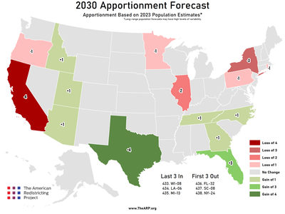
As of July 1, 2023.
Congressional representation is reapportioned every decade following the completion of the decennial census. The Census Bureau's most recent Population and Housing Unit Estimates were released...
In the November 2022 Election, over 6,400 state legislative districts across 46 states were up for election (Louisiana, Mississippi, New Jersey, and Virginia did not hold state legislative election...
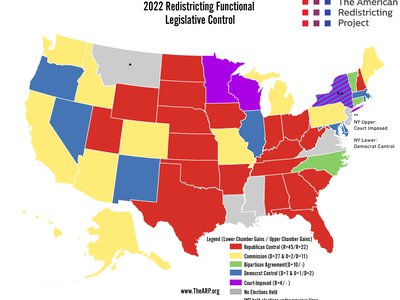
The 45 states with State Legislative elections under new lines had starkly different partisan outcomes between February 2021 & December 2022 . States are grouped into five control ...
Migration patterns from the first official county level migration data for 2020.
The data used for this analysis was provided by the Population Migration dataset from the IRS’s Statistics of Income (SOI). This dataset uses the number of tax returns filed for an approximate numb...
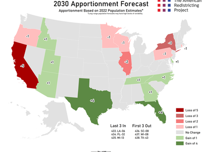
As of July 1, 2022.
Congressional representation is reapportioned every decade following the completion of the decennial census. Each year the Census Bureau produces the Population and Housing Unit Estimates Program; ...
Earl Blumenauer (D - Portland) introduced the REAL House Act, to expand the House of Representatives to 585 & create a mechanism to increase the house following each apportionment.
The Restoring Equal and Accountable Legislators in the House Act , REAL House Act , would remove the cap of 435 total seats in the US House of Representatives in order to reduce the average congre...
Redistricting terms related specifically to geography and drawing maps.
Block Assignment File The file format for many of the geographic products that the Census Bureau provides to states and other data users containing the small area census data necessary for leg...
Redistricting terms related specifically to the Decennial Census and U.S. Census Bureau.
Alaska Native Self-identification among people of Alaska Native descent. There were six main Alaska Native groups in the 2020 Census: Alaska Athabaskan Aleut Inupiat Tlingit-Haida Tsimsh...
Redistricting terms related specifically to the redistricting and electoral process.
Alternative Population Base A count other than total population from the federal decennial census that is used for redistricting. Apportionment After each Decennial Census, the populat...

Redistricting control as of January 18, 2023.
Congressional Redistricting Republican Control (20 States - 187 Seats): Alabama, Arkansas, Florida, Georgia, Indiana, Iowa, Kansas**, Kentucky**, Mississippi, Missouri, Nebraska...
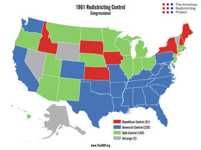
In the United States, the responsibility for redistricting (the redrawing of election districts) is given to the state legislatures under Article I, Section 4 of the Constitution. After each dece...